

Description
DESCRIPTION
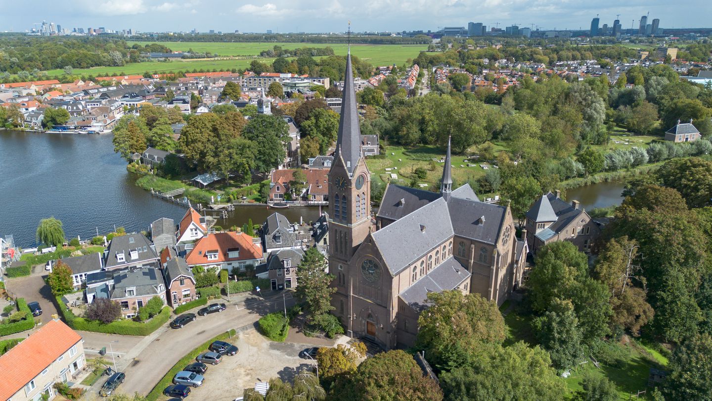
The Urbanus complex in Ouderkerk aan de Amstel at Rondehoep Oost 31 / Achterdijk 1-3 and Schoolweg comprises the following components:
1. The Urbanus Church including parking area
2. The rectory including the rose garden
3. Development land
The cemetery is excluded from the complex to be sold. It is the parish’s preference to sell the complex as one entity. But the sale of the individual parts is also possible. The principle is that the complex will be delivered free of rent and use.
The buyer of the church will assume the obligation to preserve and maintain the Mary Chapel within the church and to keep it accessible. The buyer of the development land will be obliged to construct a community building of approximately 200 m² with outdoor space near the cemetery. This must be a stand-alone building located near the cemetery and parking area. This building, including the land, will remain in ownership of the parish.
LOCATION
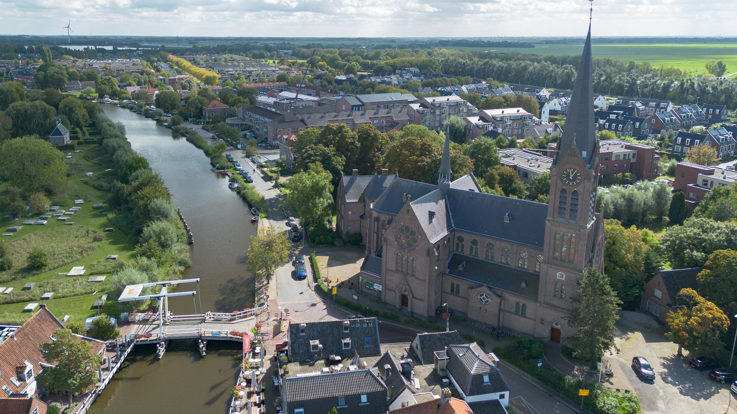
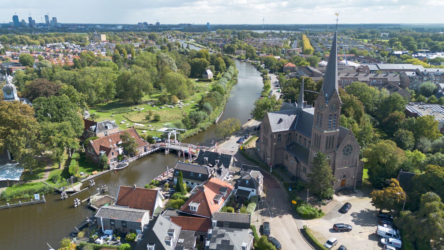
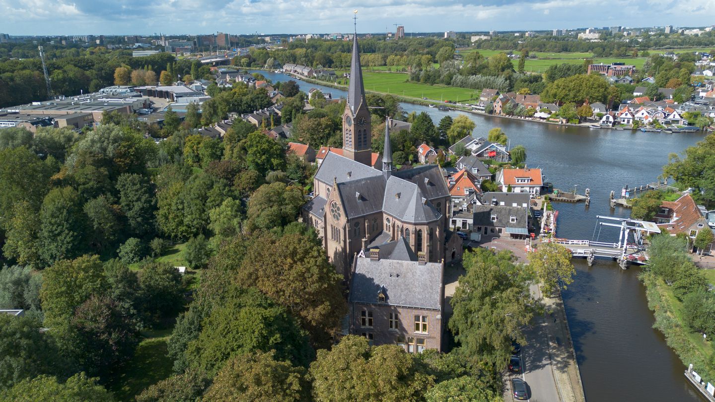
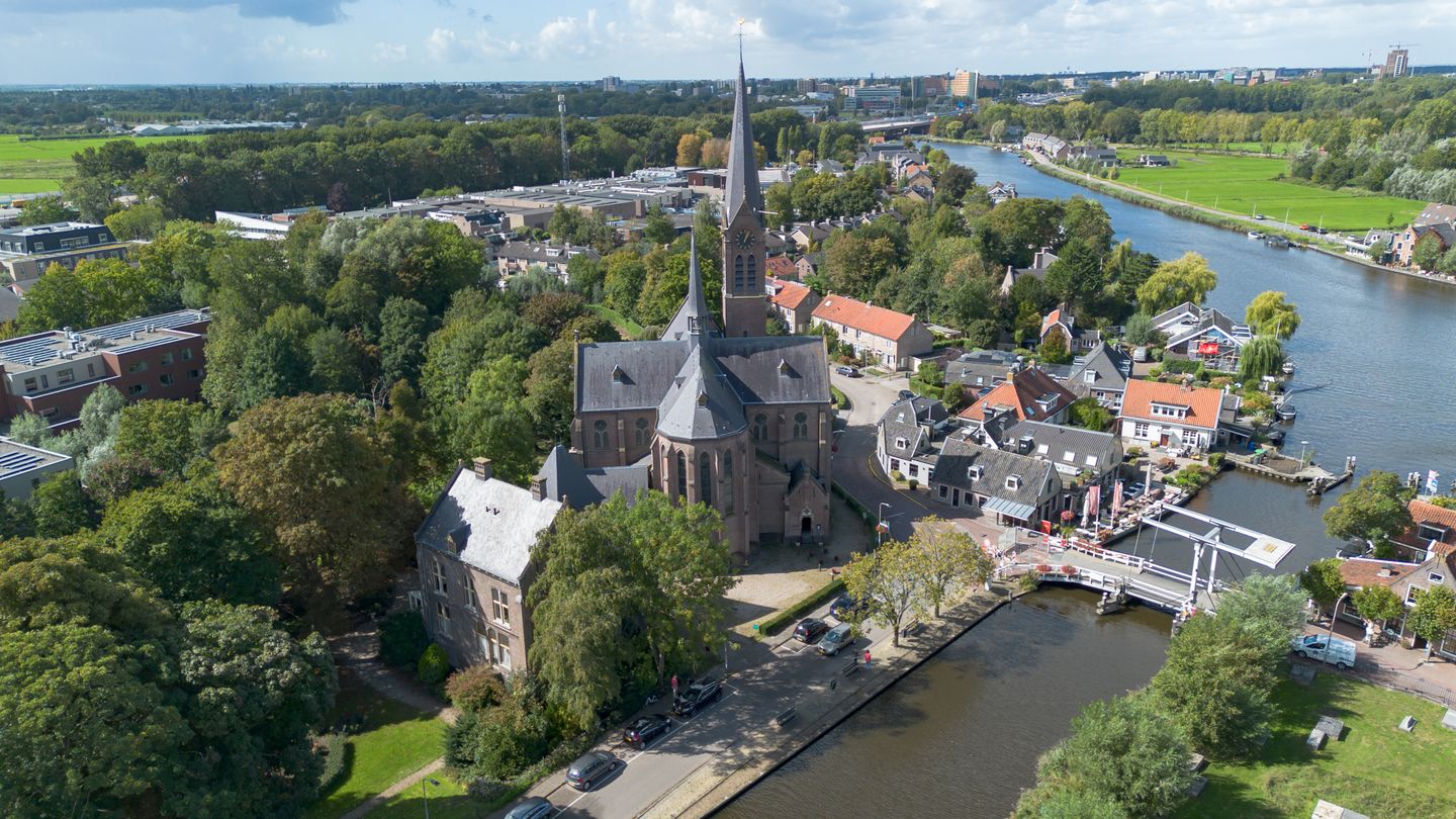
The complex is centrally located in Ouderkerk aan de Amstel, directly near the Amstel River and within short distance of Amsterdam, Amstelveen and the A2, A9 and A10 highways. The green and historic surroundings attract not only residents but also entrepreneurs, visitors, and tourists.
The St. Urbanus Church and rectory offer a unique opportunity for the redevelopment of an iconic building in a sought-after region. The possibilities for future use are versatile, making this property attractive to investors, developers, and end users seeking a distinctive location.
ACCESSIBILITY
By car
• Approximately 4.5 km to the A9
• Approximately 3.4 km to the A2
By public transport
• Approximately 9 minutes’ walk to the nearest bus/tram stop
• Approximately 6.6 km to the nearest train station (Bijlmer/Arena)
DESCRIPTION OF THE COMPLEX
Rectory
The former rectory is a listed national monument. Adjacent lies the so-called rose garden, which forms part of the protected village view.
The current zoning is “social use” but it has always been used as a service residence. The rectory is highly suitable as a residential home. Any rezoning to residential use must be arranged by the purchaser.
According to the measurement report, the rectory has a gross floor area of approximately 700 m² and a usable area of about 575 m².
This floor area is divided as follows:
• Basement: 152.4 m² GFA of which 120.8 m² other
• Ground floor: 218 m² GFA of which 185.6 m² usable residential area
• 1st floor: 158.8 m² GFA of which 141.9 m² usable residential area
• 2nd floor: 22.8 m² GFA of which 16.6 m² usable residential area
• 3rd floor: 145.8 m² GFA of which 112.8 m² usable residential area
Total: 698.6 m² GFA and 456.9 m² usable residential area
Church
The church building, including the organ, is a listed national monument with many monumental features inside.
Below is the indicative calculation of the gross floor area of the church building:
• Ground floor: 755 m²
• 1st floor: 40 m²
Total: 795 m² GFA
Development Land
In June 2020, the municipality issued a positive advisory opinion on the development of the Urbanus complex. This development is laid down in the document “Concept Development Grounds Urbanus Church dated 26 June 2020.”
This plan (approximately 27 housing units with parking) therefore forms a solid basis for the redevelopment of the lands belonging to the Urbanus complex. (See attached photo)
CADASTRAL DATA
Municipality: Ouder-Amstel
Section: G
Numbers: 960, 967, 1580, 1582, 1584, 1585, 1586, 1587
The parcels together total 11,466 m². This excludes the cadastral parcel on which the cemetery is located.
PARKING
Parking facilities are available on the various parts within the complex or will form part of the development plan to be realized.
ZONING PLAN
Applicable is the Environmental Plan Municipality of Ouder-Amstel, adopted on 21-12-2023. Specifically, the Zoning Plan Municipality of Ouder-Amstel, final as of 20 June 2013, applies. Zoning “Social Use” includes social facilities with subordinate sports facilities, as well as related gardens, yards and grounds, roads and paths, green areas, parking and water management facilities. Furthermore, several specific designations apply within the relevant area — for example, the red-lined parcel designated as a cemetery.
The former rectory is a national monument. Adjacent lies the so-called rose garden, part of the protected village view. The current zoning is social use but it has always served as a service residence. The rectory is highly suitable as a private home. Any rezoning to residential use must be arranged by the purchaser.
If you would like more information about this project, you are requested to return the signed confidentiality agreement. Upon receipt, we will send you the full information package.
SALES PROCESS
• Viewing days: 5 and 14 November 2025 (registration required in advance via email:
• Bid deadline: 29 January 2026
• Transfer intended no later than: 31 March 2026
CONTACT DETAILS FOR QUESTIONS
Eric Annaert: / +31 6 53 59 14 13
Michel Notebaart: / +31 6 30 32 84 70
Josien Kuipers: / +31 6 26 66 83 64
The Urbanus complex in Ouderkerk aan de Amstel at Rondehoep Oost 31 / Achterdijk 1-3 and Schoolweg comprises the following components:
1. The Urbanus Church including parking area
2. The rectory including the rose garden
3. Development land
The cemetery is excluded from the complex to be sold. It is the parish’s preference to sell the complex as one entity. But the sale of the individual parts is also possible. The principle is that the complex will be delivered free of rent and use.
The buyer of the church will assume the obligation to preserve and maintain the Mary Chapel within the church and to keep it accessible. The buyer of the development land will be obliged to construct a community building of approximately 200 m² with outdoor space near the cemetery. This must be a stand-alone building located near the cemetery and parking area. This building, including the land, will remain in ownership of the parish.
LOCATION
The complex is centrally located in Ouderkerk aan de Amstel, directly near the Amstel River and within short distance of Amsterdam, Amstelveen and the A2, A9 and A10 highways. The green and historic surroundings attract not only residents but also entrepreneurs, visitors, and tourists.
The St. Urbanus Church and rectory offer a unique opportunity for the redevelopment of an iconic building in a sought-after region. The possibilities for future use are versatile, making this property attractive to investors, developers, and end users seeking a distinctive location.
ACCESSIBILITY
By car
• Approximately 4.5 km to the A9
• Approximately 3.4 km to the A2
By public transport
• Approximately 9 minutes’ walk to the nearest bus/tram stop
• Approximately 6.6 km to the nearest train station (Bijlmer/Arena)
DESCRIPTION OF THE COMPLEX
Rectory
The former rectory is a listed national monument. Adjacent lies the so-called rose garden, which forms part of the protected village view.
The current zoning is “social use” but it has always been used as a service residence. The rectory is highly suitable as a residential home. Any rezoning to residential use must be arranged by the purchaser.
According to the measurement report, the rectory has a gross floor area of approximately 700 m² and a usable area of about 575 m².
This floor area is divided as follows:
• Basement: 152.4 m² GFA of which 120.8 m² other
• Ground floor: 218 m² GFA of which 185.6 m² usable residential area
• 1st floor: 158.8 m² GFA of which 141.9 m² usable residential area
• 2nd floor: 22.8 m² GFA of which 16.6 m² usable residential area
• 3rd floor: 145.8 m² GFA of which 112.8 m² usable residential area
Total: 698.6 m² GFA and 456.9 m² usable residential area
Church
The church building, including the organ, is a listed national monument with many monumental features inside.
Below is the indicative calculation of the gross floor area of the church building:
• Ground floor: 755 m²
• 1st floor: 40 m²
Total: 795 m² GFA
Development Land
In June 2020, the municipality issued a positive advisory opinion on the development of the Urbanus complex. This development is laid down in the document “Concept Development Grounds Urbanus Church dated 26 June 2020.”
This plan (approximately 27 housing units with parking) therefore forms a solid basis for the redevelopment of the lands belonging to the Urbanus complex. (See attached photo)
CADASTRAL DATA
Municipality: Ouder-Amstel
Section: G
Numbers: 960, 967, 1580, 1582, 1584, 1585, 1586, 1587
The parcels together total 11,466 m². This excludes the cadastral parcel on which the cemetery is located.
PARKING
Parking facilities are available on the various parts within the complex or will form part of the development plan to be realized.
ZONING PLAN
Applicable is the Environmental Plan Municipality of Ouder-Amstel, adopted on 21-12-2023. Specifically, the Zoning Plan Municipality of Ouder-Amstel, final as of 20 June 2013, applies. Zoning “Social Use” includes social facilities with subordinate sports facilities, as well as related gardens, yards and grounds, roads and paths, green areas, parking and water management facilities. Furthermore, several specific designations apply within the relevant area — for example, the red-lined parcel designated as a cemetery.
The former rectory is a national monument. Adjacent lies the so-called rose garden, part of the protected village view. The current zoning is social use but it has always served as a service residence. The rectory is highly suitable as a private home. Any rezoning to residential use must be arranged by the purchaser.
If you would like more information about this project, you are requested to return the signed confidentiality agreement. Upon receipt, we will send you the full information package.
SALES PROCESS
• Viewing days: 5 and 14 November 2025 (registration required in advance via email:
• Bid deadline: 29 January 2026
• Transfer intended no later than: 31 March 2026
CONTACT DETAILS FOR QUESTIONS
Eric Annaert: / +31 6 53 59 14 13
Michel Notebaart: / +31 6 30 32 84 70
Josien Kuipers: / +31 6 26 66 83 64

Surroundings
Ouderkerk aan de Amstel, Ouderkerk aan de Amstel
Discover locations in the neighborhoodMap
Map is loading...

Cadastral boundaries
Buildings
Travel time
Gain insight into the reachability of this object, for instance from a public transport station or a home address.